The "Vaj Forest" covers the north-facing slope of the Bric del Vaj, one of the highest elevations of the Torinese Hill. The relatively high elevation, the type of soil and the rather cool microclimate resulting from the exposure have ensured the survival of a beech forest, which is now protected by the Bosco del Vaj Nature Reserve. The area is of particular naturalistic value because it is a real living relict of the forests that existed at the time of the ice ages. From the top of the hill the view of the Alps and the Po Valley below is very interesting, especially on fine winter days when the sky is clear and the trees are leafless. If you wish, you can reach it with a short walk starting from the Castagneto Po picnic area. Getting there on foot from Chivasso station, following the "Sentiero Berruti," however, affords an altogether different satisfaction and allows you to admire the mouth of the historic Cavour Canal, one of Italy's most important irrigation infrastructures. The initial section of the Berruti Trail, which is decidedly steep, has recently been restored after some maintenance work, but if the weather is rainy it can become very muddy.
Access. Chivasso station (about 200 m).
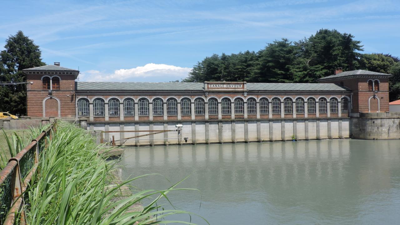
Itinerary. Leaving the station, walk along Via Roma and then, to the left, the central Via Cosola; having arrived in Corso Cavour, follow it to the traffic circle overlooking the Cavour Canal. Here cross the street and take the historic tree-lined avenue (yellow sign) that runs along the canal and soon reaches the canal's large ''inlet floodgate'' and the monument to Carlo Noè, the Monferrato engineer who designed the canal.
Passing to the right of the floodgate, you enter the "Bricel River Park" and continue on a gravel road; when this forks, near a fountain, continue straight ahead. Coming out on the asphalt, turn left and cross the bridge over the Po, originally built in 1858 but almost completely rebuilt after the 1994 flood. Markers of the Sentiero Berruti ("SB") - Berruti Trail, in English - begin to be visible; in this section it coincides with the GtC (Grande traversata della Collina) - Great Hill Crossing, in English. On the other side of the bridge, you cross the ex-SS 590 and come to the start of the trail proper, marked by an information board (0.20 hours). Up to this point one could also arrive by car, but the nearby parking lot is reserved for customers of the "Rio Grande" bar-trattoria. The trail climbs steeply through a dense deciduous forest and with several stair-step sections crosses what remains of a fortified line that was built in the early 18th century to defend the city of Turin. Widening out into a gentle slope to the left, our trail passes near the "Castle of Castagneto" (or Villa Ceriana, which belonged, among others, to the Bruni-Tedeschi family), with some monumental trees gracing its park. You then start climbing again and, having passed the provincial road for Castagneto, with a steeper stretch and a short descent, you find it again further upstream, following it for a few dozen meters to the right, until the junction for San Genesio (352 m, one hour), descending again on asphalt in the direction of the church.
Shortly before reaching the building, you take a small grassy road to the right that soon turns into a trail. You therefore pass below a flourishing bamboo grove and then reach a paved crossroads near a water purifier. Our itinerary briefly travels along SP103, uphill (signposted for Casalborgone), then continues to the right on Chiovino road and, past an area of small villas, takes Via Asti.
The route skirts the municipal center on an almost flat level, from which, however, if you wish, you can pass by taking a variant of the SB also marked. Following the main route, you will come to the vicinity of the elementary schools, where Via Asti ends, and proceed following the signs for Bosco del Vaj, finding the GtC marker again in this section.
The small road reaches a picnic area where the asphalt road ends (440 m, 0.40 hr) and, now with a natural bottom, overtakes the small Rio del Vaj and heads uphill into the woods. Further on, the lane tends to level out and it is possible to admire here and there the annual specimens of beech trees that led to the establishment of the nature reserve.
When you reach the "del Ròc" crossroads, where in addition to the boulders from which it takes its name there is a small fountain, you leave the GtC route to continue to the right still on the Berruti trail. The trail now becomes rather steep and reaches the high stone cross on the summit of Bric del Vaj (583 m, 0.30 hours).
Descent. As an alternative to the route taken on the way up, you can continue along trail 107, which descends the hill on the opposite side of the route taken on the way up. When you reach a picnic area, you leave a branch to the left that leads to an antecedent of the Bric and continue the descent to the right along a lane that soon leaves the woods and becomes paved. Converging on a more major road (San Raffaele road, which then changes its name to Ossole road) follow it to the right. After a short ascent, the road begins to descend toward the center of Castagneto but, having reached the tiny Church of San Rocco (497 m, 0.30 hours), our trail turns left into Via Giaccona (arrows and GtC marker). After some tens of meters, you quit the asphalt road at a votive pillar to take a grassy lane that descends to the right and which, having reached some recently built houses, becomes paved and then emerges at a T-junction on via Cimenasco. Keeping to the right, you then take the small road that corresponds to house numbers 36/38, always marked GtC, and flank the outbuildings of Villa Lupo. At the next junction you start down a dirt lane (GtC/sent. 102) which, leaving the marker 103 on the right, descends among dense trees. It rejoins the asphalt at a lane that gives access to a private property: following the small road downhill, this becomes gravel and, after passing some houses, reaches the ENEL Green power plant in Galleani and opens onto ex-SS 590. Following the road to the right (it is convenient to use a small service road to the houses that overlook the road for a stretch) you return to the Chivasso bridge, and from there to the station. As an alternative to passing through the river park, it is perhaps more interesting to continue straight on via Po and return to the starting point via the historic center of the town (1.30 hours).
Testo di Aldo Molino e Filippo Ceragioli
Per maggiori info: http://www.piemonteparchi.it/cms/index.php/territorio/sentieri-provati/i...